The White Cheremosh
The right tributary of Cheremosh together with Black Cheremosh give the beginning to Cheremosh. The length is 51 km, the square of drainage area is 632 square km. This river is a nature border between Chernivtsi and Ivano-Frankivsk regions. It begins after merger of Perkalab river and right Sarata river in Perkalab village on the height of 947 meters above sea level.
Perkalab river gathers water from the slopes of Grynyav mountains and from western slopes of Black Dil spine (the highest point is Chorny Dil mountain, 1493 m), and Sarata river gathers water from the eastern slopes of Black Dil spine and from western slopes of Yarovytsya spine (Yarovytsya mountain, 1580 m). Black Dil is a spine with steep cliffs , limestone caves and unique flora.
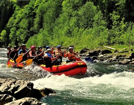
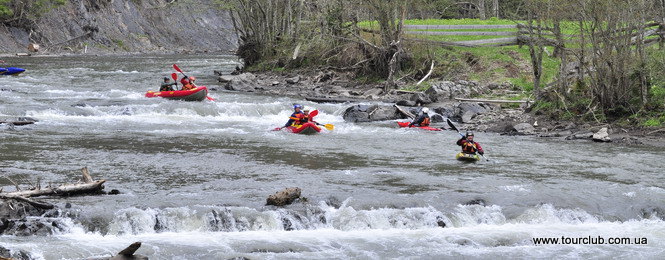
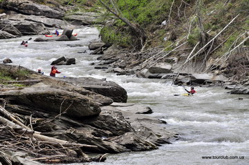
From its beginning White Cheremosh flows in a narrow valley with very steep slopes covered by pine forests, only in the places not far from the mouth of river there are small extensions of valley where the villages are located. The slope of channel reaches 14 m/km, the stream is very fast. The rapids are difficult for them passing, there are all selection of obstacles on the river, which are typical for the mountain river.
For the water regime of Cheremoshes, as for many Carpathian rivers, the spring flooding is typical during snow melting in the mountains. In summer water also rises quickly, though this summer flooding is short. The best time for the rafting on White Cheremosh is spring months, when the high level of water is stable. Formerly there were water-regulating structures, hamovanky (water-reservs), dams on the river etc. They accumulated water in a small water storages in order to use it for rafting timber. This system operated all year, except some of winter months.
Now only memories about exotic profession of the mountain river, songs and poems about brave rafters remained. Today bokorashi (water collectors) are only mentioned sometimes: darabs (rafts) became a legend now. In August 1979 the last raft of Carpathian forest passed through Cheremosh. Now the water-regulating structures are dismantled and White Cheremosh entered its usual riverbed, which shallows in summer and in spring, and during the rains is filled and wild, casting with fury on the stone banks.
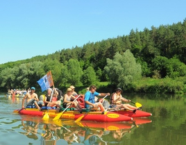
Rafting direction
During spring water the rafting on catamarans can begin from the small village Lower Yalovychora located in the mouth of the right tributary of White Cheremosh – Yalovychora river. It is in 7 km lower from the merger of Perkalab with Sarata and from the beginning of the White Cheremosh.
- First kilometers make you to work hardly. High speed of stream, huge number of underwater stones creates pretty standing waves and difficult line of rafting on the river, when you need to maneuver between big stones in the riverbed all the time.
- Lower there is a simple rapid across all river with considerable reduce of water.
- Long shallow area on the river with a significant number of rocky ledges and waves.
- The cascade rapid with a significant difference of height, difficult line for movement, high standing waves, after it – shallow.
- Before the left tributary of Gostyvets there are several more ordinary rapids, though all river is endless shyvera (shallow part of river with stones).
- The narrow valley is little bit divided here, created an oval bowl of the past reservoir of the dam Marien. Now there is a bridge instead of dam. The height is 800 meters above sea level. When the water level is low it’s more real to start rafting from here. From this place the kilometrage of sailing direction of White Cheremosh begins and runs until the mouth of river.
- 1,7 km. The rapid Horby, 780 m, the difference of altitudes on the rapid is pretty significant. The rapid has three areas. The first one consists of several low ledges across the all riverbed. In the west from right bank a small creek falls into rapid, behind of it the bank rises as high rock wall. The left bank isn’t high, is fortified by rustic wall, and there is a small meadow on it. All this situation formed after smooth turn left. Second area is a high ledge in the right turn of riverbed with a height of 0,8 m and casting of water on the rustic wall of the left bank. Third area is a randomly scattered big stones in the riverbed and several low ledges.
- 2,5 km.The mouth of the tributary of Lopushna river.
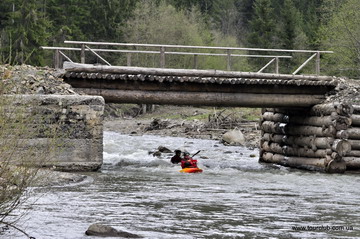
- 3,1 km. The mouth of Stryzhyvsky river, 765 m. The bridge over the White Cheremosh. Hostivetske forestry.
- 4,1 km. Goloshyna village. The bridge over White Cheremosh.
- 4,8 km. Goloshyna village. Hanging footbridge over White Sheremosh, 725 m.
- 8,2 km. The place of past dam-hamovanka in Solotvyno village, 720 m.
- 9,2 km. The beginning of shyvera near Tarnachka village. In the riverbed the scattered big stone and plates create a big spin wave in the exit of shyvera.
- 10,5 km. The beginning of the rapid Dudky, 690 m, the difference of altitudes on the rapid is about 15 m on 1 km of total length of the rapid. The rapid is 1 km of length, it is located on the big and smooth left turn of river. The right bank of river is high, abrupt, bosky. Left one is low, empty with rare trees. Rapid consists of many ledges, which height grows with the reaching of its exit. Especially difficult exit of the rapid is there, where big stone blocks in riverbed, water pressure on the right bank and high standing wave add. The rapid ends with a cascade of low ledges.
- 11 km. Hanging footbridge over White Cheremosh. It is an reference point of the beginning of rapid Voritets.
- 11,2 km. Start of the rapid Voritets. It is a most difficult, dangerous in the basin of Cheremoshes for passing. The high-water river is very compressed by stone banks from both sides, it flows in a narrow rock corridor with a high speed, turning one or another side. Both left and right banks on the considerable segment are fortified by rustic walls. The rapid is multistage and almost all his rock ridges are putted at angle to the stream, creating twisted water streams. The difference is very considerable, it is visible to the eye. Main problem are created by the cascade of ledges before river’s right turn, almost in the middle of rapid. Stone ridges blocks all riverbed angle-wise, and on the area about 100 m they create difference almost in 5 meters. In the end all water stream casts in rustic wall, and then it flows to rocks of the opposite bank. The review of rapid and carrying of equipment bypassing the rapid is possible on the right bank.
- 12.2 km. The hanging footbridge over White Cheremosh in the end of the rapid Voritets, 642 meters above the sea level. The footbridge hangs very low over the water.
- 15,8 km. Mouth of Probiyna river, 615 m.
- 17,3 km. Small island.
- 17,6 km. Hanging bridge in Yablunytsya village.
- 18,2 km. The remnants of concrete dam of the past hydroelectric power station in Yablunytsya .
- 19,4 km. Second hanging bridge in Yablunytsya.
- 21,1 km. Highway bridge over White Cheremosh in Yablunytsya.
- 22,3 km. Konyatyn village, bus station.
- 24,3 km. Dovhopillya village, the remnants of dam-hamovanka.
- 26,7 km. Dovhopillya village, hanging bridge over White Cheremosh, church, 530 m.
- 30,2 km. Stebni village, church, 505 m.
- 33,3 km. Mouth of White Cheremosh, 488 meters above sea level.
Getting to the Lower Yalovychora is possible by passing transport from Yablunytsya.
Lower Yalovychora is a small village with houses picturesquely scattered on the slopes, located in the place of flowing into White Cheremosh by his right tributary Yalovychora. Around it, there is Bukovynsk Eye – a small mountain lake surrounded by steep slopes, peaks Dvorelets and Mezhivsky, it is the only lake in Bykovynsk Carpathians. There is a road from the village to it.
On the slope of Gola mountain in 2 km from the village there is a hydrogen sulfide water source of Gola Mountain.
7 km higher along White Cheremosh on Sarata river there are two mineral sources near the past village Perkalab. These are small wells. A salt water, that flows from these sources, creates a creek. For its chemical composition waters of these sources belong to the mineralized waters of the specific brominated chlorine-sodium-calcium type.
In the mouth of Lopushna river on the right bank of White Cheremosh there is a small settlement of loggers with a hostel.
Near Goloshyno village on the both banks of the White Cheremosh there are chloride mineral sources. Behind the rapid Voritets the river valley little bit expands, the terraces, picturesque polonyny (woodless mountain areas) shows up, which alternates with wood areas, farther, higher on the slopes there is a continuous pine wood.
Such landscape keeps to Yablunytsya. Village is situated in the pretty wide valley, on the both banks of White Cheremosh.
Next there is Konyatyn village known because of old Vasylkivska church built in 1790. It is one of the oldest three-floor churches of Bukovyna. Dovgopillya village is connected with Ivan Franko name. Before I.Franko settled in Kryvorivnya, in summer 1898 he rested in Dovgopillya. Here he at first acquainted with Bukovyna and its people. Here the writer opened for history a name of the leader of national avengers Myron Shtolyuk (Shtola).
When he heard about Shtolyuk from local hutsuls, he supposed that this man really lived, and some time ago archive materials confirmed it.
In this village I.Franko heard about judge-mandator Godlychko, who cruelly tortured the hotsuls in serfdom period. This theme author used in his story «Hutsul king». Summer, which writer spent in Dovgopillya, was an anniversary for him: Ukrainian community celebrated 25th Anniversary of his literature activity and by the request of jubilee committee a painter Ivan Trupi came to village to paint a writer’s portrait.
Now one of them is kept in Ivan Franko museum in Lviv.
Not far from Dovgopillya there is Golovy village. Here Luka Harmatiy (1866-1924), researcher of hutsul culture, worked as a teacher. Tireless collector of hutsul folklore gave his folklore findings to V. Shuhevuch for publication in his «Hutsulshchuna» and to V. Gnatyuk – for his folklore book «Kolyadku and shchedrivku». Harmatiy’s activity as collector of household items and national art, especially metal products, is very important. Whole collection was given to Lviv ethnographic museum and something else was given to museums in Kolomya, Peterburg and Prague.
Behind the Dovgopillya river continues to flow fast in the narrow valley. In the riverbed there are small rapids, steep turning points, water pressure on some or another bank, standing waves, little islands.
In the mouth of White Cheremosh you can finish your rafting or continue it to Vyzhnytsya, or along Prut to the Chernivtsi.
The article from th book "Touristic Carpathian rivers"by Volodymyr Zakharchuk and Georgy Churchun