The Cheremosh River: Water Routes
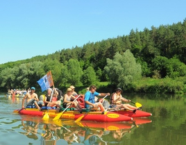
The main attractiveness of water routes in our region is their vivid individuality and diversity. On the same river one can discover the sections of various complexity, water content, grandeur and restiveness. The same river looks differently in winter, spring, summer or autumn, during abatement or flooding. That is why, it is very important to choose the place of rafting, season and weather, taking into account not only type and size of the boat but also your professionalism, experience and qualification. Bukovyna rivers suit for sailing on kayaks, paddle boats, rafts, inflatable rubber dinghies and on the Dnister reservoir you can use small sailing ships, cutters and ordinary pleasure motor ships. One shouldn't reject safety precautions as water rafting especially on mountain rivers is considered to be the extreme tourism.
The Cheremosh River
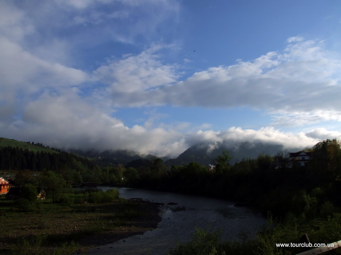
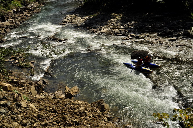
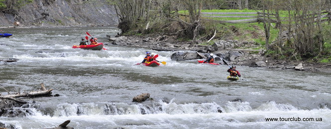
It's hard to find another river on the territory of the former USSR that would be so popular and respectable among water tourists irrespective of its relatively small length. The tradition to hold sports rafting was initiated at the end of 50s of the XX century and in 1967 near the village of Biloberizka and Petrashi the first all-Ukrainian competitions in water tourism on canoe. Since then the Cheremosh has become an avowed arena for holding national and all-Union competitions, which actually turned into international events due to participation of crews from other countries. The traditions have not been lost up to now and the international popularity of the river grows with every passing year. Why is the Cheremosh so attractive? First, it attracts by unsurpassed beauty of the nature, diversity of the very water-way and the full complex of natural obstacles peculiar for mountain rivers ranging to the highest categories of complexity. The river is full of sudden turns, rapids, shivers (chaotic conglomeration of rocks in the river), floodgates, gorges, and whirlpools that do not allow the knights of oars and a life jacket to relax even for a single minute.
The Cheremosh has two faces: mountainous and flat, consequently, after stormy scuffles and troubles in its head water you will feel the pleasure of quiet rest in its lower reaches. A very important advantage of the Cheremosh is the proximity of populated localities where you can stop for night in tourist camps or in private houses since the crucial element in any water trip is the issue of overnight stay under normal conditions: you cannot put too much equipment to a kayak or a canoe! Another important and favorable factor is the convenience of access roads and sufficiently long season of rafting -from early spring to late autumn.
So, don't waste time and go on trip to the head river, or to put it more precisely to the White Cheremosh. The etymology of the names of kindred rivers (whose names, by the way, are actually antonyms: white and black) is very interesting. It's hard to find visual colorful differences between these rivers or the chemical composition of their water. The toponymical analysis of many similar Ukrainian and foreign hydronyms has proved that the traditions go back the pagan times when the white color associated with everything right and positive and the black - with left and negative. The White Cheremosh obtains its name after the junction of two streams - the Perkalab (left) and the Sarata (right) - in a small populated locality Perkalab, which means "salty". On the right bank in the middle current of the Sarata, at least three springs with the chloride sodium water are known. These springs are protected by the state as the hydrological natural monuments. The currents themselves are strong enough for rafting on kayaks, but only after their confluence the might of the river is sufficient for rafting on canoes, inflatable rafts, boats and paddle boats. When the water level is normal the width of the White Cheremosh exceeds 10 - 15 meters and the average depth is no less than 0.4 - 0.5 meters.
It is wise to start rafting from Perkalab (when the water level is sufficient) since one can get here from Chernivtsi, Berehomet or Vyzhnytsya only in the second half of the day. That is why it is worth to stop, prepare boats for rafting, have a good rest and stay overnight in the forestry, on the base for conducting training programs of Chernivtsi National University or in currently vacant buildings of liquidated forestry post. If you have time you may go on an excursion along the valley of the Perkalab and in two kilometers you will encounter the ruins of the old dam, which was the biggest and the most beautiful in that region. Formerly, the dam generated water for rafting. A picturesque lake existed until 1985 and the smooth surface of the river reflected emerald woods and colorful cliffs relayed with shale. Rafting down the rivers had vivid ethnographic hutsul color, however, it caused significant losses for river ichthyofauna and resulted in the destruction of riverbanks, therefore it was recognized as ecologically inexpedient. And in economic "competitions" motor transportation has won.
 It is recommended to start rafting from the place of confluence of two steams, down the low automobile bridge over the Perkalab, where the absolute height over the sea level is 950 meters. The average speed of the current ranges from 1 to 2 m per second; however, because of vortexes and pressures one should be very careful. Thus, the speed of boats will slow down. Here, on the section between the villages of Perkalab and Nyzhniy Yalovets, the river rushes to the north-east through the tectonic structure of Yarovytsya - Hostiv strands. That is why it is narrow, with steep cliffs and the current is wavy. The motor way runs along the left bank at the very water edge and sometimes as a result of floods may be ruined. Bank degradation with trees fallen down is also frequent. Consequently, the situation is very changeable and one should be very careful as to such obstacles on the way. Be careful: down to the junction of the left tributary of the Oglend (6 km from the start) there is wooden bridge in the emergency state. The length of the section Perkalab - Nyzhniy Yalovets is 7 km, the river-bed fall is 88 m (12.6 m/km). At normal waters and absence of significant obstacles the distance may be covers in 2 hours.
Near the village of Nyzhniy Yalovets, rather big and deep right tributary of the Yalovychora flows into the White Cheremosh. From this point the valley of Cheremosh takes a sharp north-west turn along the major tectonic structures, that is why the valley somewhat widens, and the very river becomes more solid. Stopping in the village you can take a rest, stay overnight and go on a small excursion to lake "Hirske oko", which unique for the Bukovyna Carpathians. The lake is only 2.5 km away when you go along the right tributary of the Yalovychora. Those interested may take an inflatable boat and learn the bottom of this beautiful reservoir with wonderfully clear water, surrounded with steep forest-covered cliffs. It's strange but the origin of the lake is still unknown. From the Nyzhniy Yalivets you can start rafting even at the time of average water content.
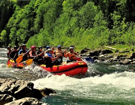
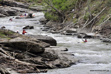
Rafting is recommended on kayaks, canoes, and inflatable rubber dinghies and paddled boats. It should be mentioned that sailing along the White Cheremosh is harder than along the Black Cheremosh. Some of the obstacles are insuperable for kayaks and canoes and require carrying them by land. Therefore, for conquering such sections it is desirable to have experience in rafting down the rivers of at least the third category of complexity. The peculiarity of this section of the river is the meandering of the river-bed at the bottom of the valley with regular rotation of steep right and left banks and right and left pressing. The speed of the current grows - at some places up to 10 km per hour, and the very rafting becomes very interesting. In 500 meters down the mouth of the Yalovychory after the first left turn there appear half meter coincident waves and then suddenly - one meter high rapids as wide as the entire river, which is to be passed around from the left side. The following 600 meters are continuous rapids with coincident waves up to 0.7 meters high.
Down the river there is sharp turn to the right and getting through the canyon it forms 8-cascade rapids with the 7-meter overfall. At this very point helmets and life jackets will be very helpful. Farther the river-bed rests against the left steeper slope of the valley. There are some rapids but they are not very difficult to pass. On the 14th kilometer from Nyzhniy Yalivets the lefty Hostivets stream flows into the river and the river-bed becomes quieter and in 2 kilometers we approach the half-destroyed wood en dam of the former dike dam Marien - at the mouth of the left tributary, which has a similar name. After water discharge the river-bed knocked down at fluffy silts, that is why it is necessary to carry the boats along the stream-bed and to the left of the motor road. You may also have a short rest by the houses of a small village.
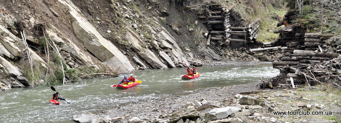
The length of the section Nyzhniy Yalovets - Marien dam is 9 km, the overfall of the river-bed is 77 meters (8.6 m/km). Under normal conditions of water it takes 2.5 - 3 hour to overcome this distance. From the Marien dam the White Cherermosh makes a sharp right turn and breaks through the gorge and tectonic structure of strands Hrebenyshche - Marien. Right after the dam the river-bed gets narrower and there appear numerous shivers and pressings. Half kilometer down the first serious rapids "Horby" (hills) begin. The first part of the rapids (450 meters) consists of cascades that cross the river bed. They are formed of thick siliceous and ordi nary sandstone of the erosion made layers of rock. The rapids are to be passed in the middle. Then the current carries the boats to 0.6 - 0.8 meter high waterfall with the pressure to the left bank. It is safer to pass it from the right bank. The final 400 meters of rapids are represented by huge boulders chaotically scattered along the entire river-bed and coincident waves. After each flooding the general picture of the rapids some what changes, therefore, before starting a river journey it is recommended to visually inspect the rapids from the bank and choose the most optimal route. The rapids "Horby" is greatly appreciated by the sports rafting experts that is why the majority of serious rafting events start from the Marien dam. Farther up to the mouth of the right tributary the river-bed is a continuous cascade of rapids and shivers with high speed current and coincident waves of various heights and provides not a single minute to relax. The distance from the Marien dam to the Lopushna river is 3 km, the river-bed fall is 28 meters (9.3 m/km), duration of the passage - one hour. Down the mouth of the Lopushna and till the automobile bridge small rapids and shivers continue but the current gets somewhat slower. From this place along both banks of the White Cheremosh lies the village of Holoshyna.
Having passed the second automobile bridge it is desirable to choose the place for taking a rest and, perhaps, an overnight stop. The village is famous for its mineral water springs containing sodium and calcium chloride with bromine as well as some springs with oil signs in water. The distance between the Lopushna and the village of Holoshyna is 3 km, the river-bed fall is 6 meters (2 m/km), duration of the passage -one hour. From the village of Holoshyna the speed of the current sharply increases. Three kilometers down where the Cheremosh starts gnawing through the tectonic structures of the mighty strand "Maksyments", the river suddenly makes a right turn and creates a steep meander. In front of the meander there remained the remains of the former Solotvynska dike dam; therefore one should be very careful. Making a semi-circle, the river rests against the steep left bank and the river-bed presents another portion of pleasure. Water currents break through the cross sandstone plates and create a screw-like billow able to turn upside-down not only kayaks and canoes but also paddle boats.
Having some rest on the quiet one-kilometer section near a small village of Tarnachka located on the left bank, the river enters another steep meander and presents you with another difficult rapid "Dudky". It consists of two benches. On its upper bench the current is crossed by nine indented stone stripes - steps with increasing hade, which turns into a short strait section of high speed cur rent. Then the meander takes a sharp left turn where another bench begins. It is studded with huge lumps with high coincident waves. The rapids end with several spillways. Therefore, those who conquer the White Cheremosh for the first time, it is expedient to make preliminary investigation and assess his/her own abilities before starting a journey. However, at these rapids the tourists have only training. In 300 meters starts the exam in water-sports maturity.
The rapid "Voritsya" is the hardest and the most dangerous of all the Cheremosh rapids to pass. The river enters a half-kilometer rock canyon with 14 cascades and the river-bed narrows in some places up to 3 -5 meters. The main complexity is presented by "steps", which were formed by erosion ground breasts of firm layers of sandstone that cross the river. From the steps the water presses the left wall with its entire mass and then very quickly it rebounds to the cliffs of the right bank. As a rule very few manage to hold out onboard. And for kayaks, canoes and inflatable rubber dinghies "Voritsya" rapids are closed. It's better not to risk and carry the boats around this section by land. The motor road is nearby, on the left; on the right the path used many times is available. To reduce the content of adrenalin and to take a rest it is recommended to stop on the right bank not far from the village of Play. The distance Holoshyna - Play is 5 km. Fall difference is 100 meters (20 m/km). Under normal conditions of water, skillfulness of participants and God's assistance the distance may be covered in one hour. To secure participants against various possible misfortunes and to save the equipment it is recommended for free fans to arrange a control post down the "Voritsi" rapids and catch every thing related to water tourism from the river. In damp and cool weather it's wise to set a bonfire and meet heroes with hot tea or coffee. A glass of vodka won't be out of place as well.
Down the village of Play the Cheremosh gets quieter if not to take into account periodic shiver sections with rotating left-right pressings. In four kilometers the left tributary Probiyna joins the Cheremosh. The river gets full-flowing. In another two kilometers the gorge widens and we get into the internal Pulyla lowlands. Flood-lands get wider and the first islands appear. From both sides there are cozy houses of the villages of Yablonytsya, whose left bank part is in Ivano-Frankivsk oblast and the right bank part - on Bukovyna side. Here, there remained reinforced- concrete remainder of the former dike dam and you have to be very careful. In Bukovyna Yablonytsya it's worth getting acquainted with the structures of a small derivation-type hydro-electric power station. A concrete channel - chute with a significantly smaller tilt of the river-bed is laid out from the former reservoir created by the dike dam. In two kilometers the obtained difference of heights amounts to 12 meters. It is sufficient for electric generator operation. After finish incomplete electrification of mountain regions, the hydro-electric power station has not been in operation for almost 25 years, however, new tendencies in the use of traditional and non-conventional power sources will sooner or later cause to return to hydro-electric power stations, such eco logically beneficial type of energy and to renew hydro-electric engineering of mountainous villages. It's also interesting to follow the change of the valley. The bottom of the valley in the first and second overflood-land terraces gets rather wide (400 - 500 meters); here one can see villages, urban villages and small ploughed fields. And the river-bed together with flood-lands run into the bottom, detaching in the bottom and on banks the globular sediments of various rocks - sand stone, limestone, mudstone and siltstone. In the village of Konyatyn there is the first automobile bridge that connects both banks of the White Cheremosh. If you feel like that you may stay for a rest or an overnight stop in private houses. The distance Play - Konyatyn is 10 km, fall difference is 90 meters (9 m/km), and the distance may be covered in 3 - 3.5 hours. Following the current the river becomes a little bit slower; the river-bed gets wider. When the water is low, shivers and slantwise jags of sandstone layers may cause troubles. Approaching the village of Dovhopillya you should pay attention to the remains of the former dike dam. In the center of the village the river makes a sharp knee-like turn with strong pressings of water towards the shores. The character of the river-bed doesn't change up to the village of Stebny: the current is rather strong.
The distance Konyatyn - Stebny is 9 km, fall difference is 55 meters (6.1 m/km), and the distance may be covered in 2.5 - 3 hours. In Stebny the White Cheremosh takes a sharp left turn to the north-west along the first strand of external middle lands (Kamyanets) and the same way, down the village of Shepetky it takes a sharp turn to the north-east and enters a narrow canyon. The river-bed is full of coincident waves; however, on quiet places there are pebbly islands. Suddenly, to the right and to the left the panorama of the mountains exposes. In front of you there appear the houses of the village of Usteriky and in some minutes the huge river - the Black Cheremosh - flows into the White Cheremosh from the left. From this very point the Cheremosh starts and acquires its might and impressiveness. Some hundred meters before junction the suspended pedestrian bridge stretches over the river.
On one of the isles you can set up a camp and arrange an overnight stop. Usually, under unfa vorable weather conditions it's better to arrange a bivouac on high banks: during heavy showers the level of water in rivers rises by several meters in an hour. The distance Stebny - Usteriky is 4 km, he fall difference is 22 meters (5.5 m/km), and the distance may be covered in 1 - 1.5 hours.
From the village of Usteriky, the Cheremosh sharply turns to the south east, splitting into several river-beds. Every time conquering this route you have to choose the best new variant, since after floods the situation changes radically. In some time the river-beds join together, and the current exceeds 25 - 40 meters, the depth ranges from 0.4 - 0.5 meters on rifts to 2 - 5 meters at the places of water pressings. The speed of the current in middle waters is 1.2 - 1.5 m/second, and at chutes - 2 - 3 m/second. Then, the river turns to the left and in the village of Ust-Putyla, down the new automobile bridge it takes another big right tributary - the Putyla. The distance Usteriky - Ust-Putyla is 4 km, the fall difference is 22 meters (5.5 m/km), and the distance may be covered in 1 hour. Let's stop in Ust-Putyla and go on a water excursion along the tributary.
Information taken from
the guide-book "Bukovyna tourist"