The Ukrainian Carpathians: Svyodvets
The name “Carpathians” derives from Albanian “karpe” (stone), and Dacian could mean “mountain”. The ancient Polish word "karpa" means "significant irregularities", "underwater stones", "large stems or roots." The name of the people - "Carpi" - "those who live in the mountains" who inhabited the Carpathians during the Roman Empire may derive from a possible Dacian meaning - "mountains".
 |
 |
 |
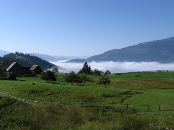
The Carpathians is a mountain system at the east of the Central Europe, on the territory of Ukraine, Hungary, Czech Republic, Poland, Slovakia and Romania. It extends for 1500 km, forming a convex arc, closing the Middle Danube plain. Maximum width is 430 km. The Carpathians is one of the main European watersheds between the Baltic and Black Sea.
Orographically one can distinguish the Western Carpathians, Eastern Carpathians (some of which are Ukrainian Carpathians), Beskid, Southern Carpathians, Western Romanian Mountains and Transylvanian plateau. The predominant heights of the Carpathians are 800 - 1200 m, maximum height - 2655 m (Mount Gerlachovsky-Shtit in the Tatra Mountains), Hoverla – in Ukraine (2061 m).
The Ukrainian Carpathians is part of the Carpathian mountain range in the West of Ukraine. The length of their upper parts of San to Suceava sources is 280 km, width is over 100 km. They occupy the territory of Transcarpathian, part of Lviv, Ivano-Frankivsk and Chernivtsi regions. The area is over 24 thousand square kilometres. Mountain ranges, separated with lengthwise lowlands and delimited with transversal deep valleys, stretch out from northwest to southeast.
Lowlands and midlands of the Carpathians are presented with mountain range of the Eastern Beskid, Gorgan and Pokutsko-Bukovina Carpathians. Central zone consists of lowlands and hollows of Vododilno-Verkhovynska region. A solid orographic core of the Polonyno-Chornohory Carpathians appears behind them. The ancient Rakhiv-Chyvchynskyi crystalline range has been preserved farther to the southwest.
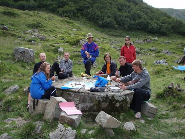
Many festivals and colourful cultural events take place in the Carpathians. For example, the festival "Hutsul brynza" (sheep cottage cheese) in Rakhiv. You will never encounter such quantity of brynza, cymbals, carpets, lizhnyks (home made wool blankets) at a place. Hosts and hostesses in uniforms, every village has its own. Here people dance, sing, treat, play at full spirit. You will be surprised with private museums of the Carpathians: Roman Kumlyk’s Museum of Antiquities in Verkhovyna with an excellent guide-host, who not only comfort with unusual stories, but also will play the ancient Hutsul instruments.
Find out more about festivals and museums in the Carpathians:
Trembitas are calling, brynza is waiting!
Carpathian miracle, or who is someone who lives near Cheremosh...
On a trip to the Carpathians and the festival "Hutsul brynza" (September, 2005)
Something about cheese and meadows
Svydovets
Svydovets mountain range is considered to be the center of Europe. This range is located in the southeast of the high-mountain part of the Ukrainian Carpathian Mountains and from the west surrounds the place where there is a geographical centre of Europe (near the village of Kruhlyi, Rakhiv district). It is marked by a stele, set on the right bank of the river Tisza and a geodesic sign with the inscription in Latin: "Permanent, accurate, eternal place."
 |
 |
 |
Svydovets range lies in the northeast of the Transcarpathian region in the interstream area of the rivers Teresva and Black Tysa. The northern slopes of the range are steep with alpine terrain features (massive blocks of bottom moraine, rocky walls and ridges). The upper part of the range is open and covered with subalpine and partly alpine flora and meadows. The forest boundaries are low enough, the northern slopes are covered with spruce forests and southern – with spruce-beech and beech forests. The river Black Tysa, the source of Tysa, one of the fullflowing rivers of the region flows out from Svydovets. The highest peak of the range is Blyznytsya mountain (1883 m).
 The peaks of the Svydovets Range
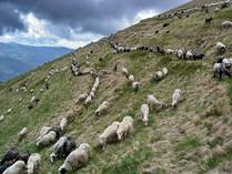


Blyznytsya, 1883 m
Velykyi Kotel, 1771 m
Dogyaska, 1764 m
Tataruka, 1711 m
Ungaryaska, 1708 m
Stig, 1707 m
Tempa, 1635 m
Pidpula, 1634 m
Berkyaska, 1555 m
Blyznetsi (Gemini) The name comes from similarities of two tops. The two highest tops in the eastern part of the Svydovets range within Rakhiv district of Transcarpathian region. Located close and similar in form. The height of the higher (southern) top is 1882 m. From the north Blyznetsi are limited by the mountain Dragobrat. The southern and western slopes are flat, oriental are steep precipices toward the extended upper part of the valley - the ice kar with the remnants of moraines and glacial lakes. They consist of sandstones, there are layers of limestones. Up to 1400 m there are pine and beech forests, crooked woods, above there are meadows.
DRAGOBRAT is the highest ski base of Ukraine, located at an altitude of 1400 m above the sea level, at the intersection of conifer forests and alpine areas at the foot of the mountain Stigh and the mountain range of Blyznyuk. Dragobrat (polish) – “cutting” (from Romanian) "drag" - "precious", "draga" - "wood transfer", "brad" - "spruce").
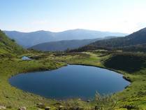
Lakes, located on the Svydovets range: Apshynets (1487 m above the sea level on the slope of Svydovets range in Rakhiv district, with the depth of more than 3 m), Vorozheska (1460 m, consists of two parts - the upper lake, with the area of 0.7 ha, with the depth of 4, 5 m and the lower lake, several times smaller, with the depth of 2 m) and Hereshaska (ice age origin, water temperature in summer is low (in July +10 ° C - +11 ° C), with little algae, the most common of the fauna are microscopic crustaceans).