The Ukrainian Carpathians: Skolivski Beskydy
The name “Carpathians” derives from Albanian “karpe” (stone), and Dacian could mean “mountain”. The ancient Polish word "karpa" means "significant irregularities", "underwater stones", "large stems or roots." The name of the people - "Carpi" - "those who live in the mountains" who inhabited the Carpathians during the Roman Empire may derive from a possible Dacian meaning - "mountains".
 |
 |
 |
The Carpathians is a mountain system at the east of the Central Europe, on the territory of Ukraine, Hungary, Czech Republic, Poland, Slovakia and Romania. It extends for 1500 km, forming a convex arc, closing the Middle Danube plain. Maximum width is 430 km. The Carpathians is one of the main European watersheds between the Baltic and Black Sea.
Orographically one can distinguish the Western Carpathians, Eastern Carpathians (some of which are Ukrainian Carpathians), Beskid, Southern Carpathians, Western Romanian Mountains and Transylvanian plateau. The predominant heights of the Carpathians are 800 - 1200 m, maximum height - 2655 m (Mount Gerlachovsky-Shtit in the Tatra Mountains), Hoverla – in Ukraine (2061 m).
The Ukrainian Carpathians is part of the Carpathian mountain range in the West of Ukraine. The length of their upper parts of San to Suceava sources is 280 km, width is over 100 km. They occupy the territory of Transcarpathian, part of Lviv, Ivano-Frankivsk and Chernivtsi regions. The area is over 24 thousand square kilometres. Mountain ranges, separated with lengthwise lowlands and delimited with transversal deep valleys, stretch out from northwest to southeast.
Lowlands and midlands of the Carpathians are presented with mountain range of the Eastern Beskid, Gorgan and Pokutsko-Bukovina Carpathians. Central zone consists of lowlands and hollows of Vododilno-Verkhovynska region. A solid orographic core of the Polonyno-Chornohory Carpathians appears behind them. The ancient Rakhiv-Chyvchynskyi crystalline range has been preserved farther to the southwest.
Many festivals and colourful cultural events take place in the Carpathians. For example, the festival "Hutsul brynza" (sheep cottage cheese) in Rakhiv. You will never encounter such quantity of brynza, cymbals, carpets, lizhnyks (home made wool blankets) at a place. Hosts and hostesses in uniforms, every village has its own. Here people dance, sing, treat, play at full spirit. You will be surprised with private museums of the Carpathians: Roman Kumlyk’s Museum of Antiquities in Verkhovyna with an excellent guide-host, who not only comfort with unusual stories, but also will play the ancient Hutsul instruments.
Find out more about festivals and museums in the Carpathians:
Trembitas are calling, brynza is waiting!
Carpathian miracle, or who is someone who lives near Cheremosh...
On a trip to the Carpathians and the festival "Hutsul brynza" (September, 2005)
Something about cheese and meadows
Skolivski Beskydy
Beskydy are devided into: West and East Beskydy. East Beskydy are located on the territory of Lviv region. It’s a system of parallel ridges, separated with wide valleys of the rivers (Dniester, Stryi and Opir) and hollows. Beech forests and grasslands dominate here. East Beskydy are also divided into: Verkhnyodnistrovski (Upper Dniester) Beskydy and Skolivski Beskydy. And in general this a tourism and resorts area (“Truskavets” and “Skhidnytsya”). There are deposits of oil, salt, springs of mineral water. Verkhnyodnistrovski Beskydy have a prevailing lowland relief, dissected with tributaries of the rivers Dniester, Stryi and others. They are covered with mixed forests. Part of East Beskydy in the interstream area of the rivers Stryi and Opir within Lviv and Ivano-Frankivsk regions is called Skolivski Beskydy. Like all Beskydy they have parallel asymmetric ridges with the following tops: Parashka, Vysokyi Verkh. Mahura and others. Dominant species of plant in a flora world are spruce, meadows (subalpine meadows).
Skolivski Beskydy is a national nature park, located in the southern part of Lviv region of Ukraine. The park covers basins of the rivers Stryi and Opir and covers an area of 35,261 hectares, of which 24 639.3 handed into constant use.
It is located within the mountain massif of the East Beskydy, which are part of the External or Skybovi Carpathians, elongated along the main axis of the Ukrainian Carpathians by one of the chains of these mountains. Actually, East Beskydy include mountain landscapes of Verhnodnistrovskyi and Skolivskyi Beskydy. The latter has a national park on its territory. Its highest peak is Mount Parashka (1268 m).
The kingdom of fairy tales and beauty
Refined aesthetic value of Beskidski landscapes, ethnographic specificity of Boiko region, hospitality of local residents provide a high recreational potential of the park. Ancient majestic forests, endless panorama of mountains against the sky, numerous mountain streams of clear water, filled with honey fragrance of flowers, air and healing mineral springs, emerald meadows attract, fascinate and give rest. This is the land of talented craftsmen, original articles of which (carved wooden items, embroidery, carpets, beads, ceramics) are valued far beyond the Carpathians.
The park attracts with loud mountain streams, noisy waterfalls of the river Kamyanka. Also known the waterfall Gurkalo on the river Mala near the village of Korchyn. Rifts occur on all streams and rivers in the park, but especially beautiful they are at the river Rybnik Maydanskyi, Pavlo and Chudylovyi flows.
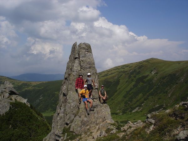
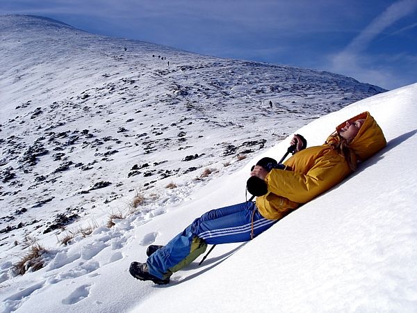
An interesting structure of the earth's surface of Skolivski Beskydy, asymmetric geological folds (ranges) are like chunks of a ploughed field leaning on each other, creating a kind of relief Skybovyi (Orivska skyba (chunk). Rock formations are common at sandstone places, they are protected as geological monuments of nature. Landslide-cliff on the slope of the river Rybnyk-Maidanskyi valley – is an interesting informative object. In general, the Beskydy mountain ranges usually have wide gentle ridges. The tops are rounded, slopes are relatively flat and mild, because of mineralogical composition of rocks - they are easy to physical weathering. All this contributes to accessibility and convenience of Beskydy in terms of their recreational development. Slopes are especially suitable for mountain skiing tourism (recreation, family).
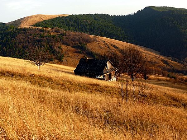
A classic example of this is Mount Trostyan, the foot of which is located 2 km from the town Slavske of Skoliv district. Slavske itself is located in the picturesque valley of the river Opir and Slavska. This all is in picturesque Beskydy, not far from (25 km) the national natural park “Skolivski Beskydy”.
Mount Trostyan is the center of mountain skiing sports and tourism. It can not compete with the height of 1300 meters, alpine skiing tracks – with those of the Alps, but it can well withstand competition with descent complexity. Thus, the most difficult is a steep central slope, which gives exciting moments of sports tests for those who dare to go down.
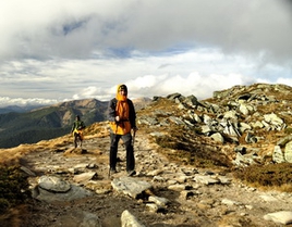
Mount Parashka
The name of mountain Parashka is associated with the name of the daughter of Prince Svyatoslav, who wanted to escape from the killers of Sviatopolk and hid on top of a mountain near Skole. However the death found her there: the girl was killed with the sword, and the people called the mountain her name - Parashka.
Mount Parashka is the most popular among tourists’ hills - from here you can see the spectacular views that impress with their beauty. Geological rocks that make the mountain are soft, easy to weathering, so the top has a rounded shape. In Beskydy one can find stone placers, steep abrupt cliffs - "hrehoty", "beskidy" (forms of so-called screes sculpture relief).
Some people link the name of the mountains "Beskydy" with a tribe of "Bess," who lived here or under another version, it comes from the Greek word that means "pasture, mountain valley." Perhaps, the second is more probable… However, from time eternal Beskydy were ancestral home for Ukrainian folks - Boyko.
Flora and fauna
...In early spring solid purple carpets of Heyfel saffron flowers appear from the undersnow, a bit later white or plain snowdrop, spring bilotsvit bloom ... In May orchids are blooming in Beskydy - bylynets dovhorohyy or komarnykovyy (gymnadenia) , zozulynets salepovyy (military orchid), spotleaf orchis travnevy. In late spring a bear onion (wild leek) blossoms, as well as soft and attractive satin rising with light purple, white or purple flowers and also poisonous (!) scopolia of the nightshade family.
In summer arnica montana, asterworth big, platanthera, lily forest, orchis sertselysti gladden the eye... Baranets zvychainy (Northern firmoss) grows in dark conifer forests. In spring purple flowers of piznotsvit osinniy (autumn crocus) appear on the meadows ... All these plants are listed in the Red Book.
Diversity and species of fauna. Here you can encounter deer, wild boar, martens - wood and stone, brown bear (within the national park they are 24). Of the rare species badger, ermine, wild cat, lynx (found 19 individuals) are found. Bisons were carried here from Bialowieza forest, they settled down well and produce offsprings.
In the outskirts of the park there are traditional resort areas - Skhidnytsia, Skole, Slavske. Of particular importance is the adjacent town Skhidnytsia where there is all-Ukrainian children's health resort "Skhidnytsia" with large reserves of mineral waters of "Naftusia” type. In addition, the park has 30 different mineral springs of balneotherapeutic action.
Archaeologists witness…
The settlement of ancient chronicle fortress city Tustan (X - XIII century) located on Uritsky rocks (Pidhorodtsivske forestry), that even now impresses with its severity and impregnability is of scientific and tourism interest.
Tustan is a duke-town, rock fortress, which existed for five hundred years (IX-XII centuries).
In the thirteenth century a historic Silk transcontinental route went through it - from China to Portugal. Why? Tustan was one of the main points for Galician salt trade (mineral galit - rock salt is a toponym of the western Ukrainian part "Halychyna" (Galicia)). Historical (written) and archaeological evidence witness - Tustan was a customs.
One of the most interesting objects of Skolyvski Beskydy is the valley of the right tributary of the river Opir – the river Kamyanka. First, a beautiful view of the river valley opens on a bridge across the Opir. Walking along the Kamyanka river we come out to a picturesque waterfall. Up the watercourse there are more fountains. On the left bank of the river there are vertical rocks, with firs and spruce clinging. This all impresses greatly, adjusts to life dynamism, poetic growth and meditation on earthly existence.
Approximately half a kilometer from the falls down a steep slope a path rises up to a unique, as for the national park, ecological object - Cranberry tract. Here, poor in underground nutrition, at a deep peat bog grows a taiga dweller - "north grapes" - cranberry marsh. There is the Lake Zhuravlyne (cranberry) in the tract (local name – Dead Lake).
After Volodymyr Hetman article