Dniester's history as a waterway
The history of Dniestr river as a waterway reaches deep in the antiquity. Herodotus mentioned the river Tiras (an old title of Dniester).
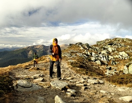
 Dniester starts at the Nothern slopes of the Carpathians, from the mount Rozlutch near the village Vovche in Lviv region. Descended from the altitude about 900m above sea level, the stream makes its way through the Precarpathia, crosses South-Western edge of Podillya uplands, flows on the Ukrainian-Moldova border, then comes to Moldova teritory and as a large navigable river falls into Dniester estuary again in the Ukrainian teritory. The length of the river is 1362km, the area of the basin is 72100 square km. The origins of the name "Dniester" is not decisively clear. It is believed, that first part of it derives from words "Dana", "Dna", "Don" - which means "the river". The second part of its name deduce from words with the meaning "southern". So, Dniester means -" Southern River". But there are also ither thoughts about origins of its name.
The watershed of Dniester borders on its south and southwest with rivers, carrying their waters to Danube - Tysa and Prut; on its west and northwest - with tributaries of Wisla: Syan and Western Bug; on the north - with right tributaries of Prypiat': Styr and Goryn'; on the east - with Southern Bug and its tributaries.
Forests in the watershed of the river cover the Carpathian slopes, while the peaks are occupied by polonynas - plains. High in the mountains dominate conifer trees, and lower - deciduous. On the plain part of the watershed there are not many forests, dominate deciduous: aok, ash, maple, linden, hornbeam, at the western part of Podillya beech is encountered. Forests occupy 13,2% of the area, swamps - 1,5%, lakes - 0,5%.
The watercourse of Dniester is very winding. The grid of streams is spread unequally. More dense at the higher part of watershed, especially right bank, where Dniester involves many abundant tributaries flowing from Carpathians. The tributaries from Roztotchya or Podillya highlands are shallow. In the middle flow Dniester involves mostly left tributaries, in lower flow they are few.
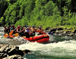
In its higher part (till Sambor) Dniester is a typical mountain river, it flows in a narrow valley between rocky steep banks. Going out on the plain within Syan-Dniesters' lowland it flows through swampy valley, its current is calm there. At the middle part in the deep narrow valley at the watercourse of Dniester come up to the surface limestones and sandstones, and below the Kamyanets-Podil'sk - even crystalline rocks ( granite, gneiss, syenite), near Yampol village they form rapids. Below Dubossar Dniester has a wide floodplain, cut up with numerous straits, lakes. The valley of the river expands to 8-16km. The lowest part of Dniester is located within Prechornomorias lowlands.
Dniester bears a lot of water. Its increased water content is caused by the fact, that upper part of the watershed situates in the Carpathians. There starts numerous and abundant right tributaries which fall into Dniester at the part from the beginning to the river Bystrytsya Nadviryanska. They start at the altitude 800-1500 meters and gives that part of Dniester features of a moutain river.
The outlet of Dniester is characterized by continuous floods, which overflows river in spring, summer and autumn. High water is caused by sudden melting of snow, by rains, and in summer by heavy downpours. Summer floods are often higer than spring ones. In flood times waters of Dniester carry much sediments.
Below Sambor, where Dniester enters Syan-Dniesters lowland, when the water level is high it gives part of its water to Vyshnia (a tributary of Syan). Once there was planned to connect Dniester with rivers of Wislas watershed by chanels.
Dniester plunged deeply into the granite foundation of Podillska upland, sometimes it flows like in a deep canyon. High rocky banks remind mountain ranges. On this banks outcrop layers of limestones, shales, sandstones. Some sections of the river are littered with rocks.
Dniester involves 386 tributaries, the main of them are: right ones - Stryy, Svicha, Limnytsya, Bystrytsya, Reut, Byk; left ones - Stryvogir, Gnyla Lypa, Zolota Lypa, Strypa, Seret, Zbruch, Smotrych, Ushytsya, Murafa.
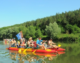
Dniester was used as a source of hydroenergy, for water suply, irrigation, shipping from the mouth to the town Galytch. Its main ports are: Galytch, Zalishchyky, Khotyn, Stara Ushytsya, Mogyliv-Podilskiy, Yampil, Soroky, Rybnytsya, Dubossary, Grygoriopol, Bendery, Tiraspol.
In the upper reaches of Dniester, on its left bank, situates the town of Sambir (Lviv region). According to ancient legends the founders of the town were residents of Old Sambir, which was ruined in 1241 by Mongol-Tatar Hordes. The settlement Pogonych was build there and later in XIV century was renamed in Sambir (The New).
In Sambir preserved the rests of fortress walls of XVI-XVII centuries, the architectural sights: The Town Hall (1668), the catholic church (1503), the hunting lodge of the king Stephan Batoriy (XVI cent.).
On the opposite of the town extended for almost 3km an island. On the river banks spreads a wide strip of smooth. There people graze cattle, hunt, harvest hay. Floodplain meadows in the area are crossed by grid of chanels, in a dry season they are a good pasture.
One of the left tributories of Dniester in its upper reaches is Vereshchytsya (length 92km). It takes the beginning in Roztotchya. It was named for heather ("veres") - shrub with small leaves forming a dense thicket.
Among right tributories of Dniester must be noted Bystrytsa. It length is 72 kilometers. Forests occupy 30% of watershed area. The name Bystrytsya means rapid stream. Not far from confluence with Dniester Bystrytsya receives inflow Tysmenytsya (the length 49km).
On the banks of twisted Tysmenytsya, in the Carpathian foothills existed once a significant town Bych. It was ruined in times of Mongol-Tatar Horde. The inhabitants of burned town became slaves of Tatars. Later Tatar Khan allowed them to build dwellings above the salt mines. Their main crafts were weaving and extraction of salt from salt-brine. So appears Second Bych. Later town was renamed in Drogobych.
In the middle of XIX century near Drogobych starts ozokerite mining, later - oil and flammable gases. In 1900-1910 in town refineries were established.
In 8km from Drogobych locates precarpathian urban village Stebnyk. It is known since XIV century. Since ancient times local population of Precarpathia extracter salt for own needs. In 1848 in Stebnyk the first common salt mine was build. At the end of XIX century there large stocks of potassium salts were discovered. Potass from Stebnyk (unlike Kalushs one) is a finished product.
O. M. YUDENYCH
"By Ukrainian rivers"